
Latest Update; July 3; 2023
New Update, July 3; 2023
I have been in on Boland Road recently, but not all the way to the falls. I had to rescue a man and a woman, who tried to drive out in the dark night, and ended up going off the road. When I arrived here on that day, I found them dragging their kayaks along the road, still 10kms to go. I advised them to put their kayaks in the bush, and I drove them all the way back to Elliot Lake.
Anyway, for the first time since I’ve been here, that’s 12 years, they are logging on the Boland Road again. There have been new roads created in here now, and the road has been somewhat improved so that the logging trucks can use it. That makeshift log bridge is no longer there, and they put a proper culvert pipe under the road now. As far as I went, the road was relatively good, although you really need to watch your speed, since hitting some of those potholes at speed could do some serious damage to your vehicle. Other than that, you should be good to go. 🙂
Just did a drive along Boland Road, and the situation has gone from bad to worse. The rickety log bridge that someone constructed over that first large washout is still there, and it’s still somewhat of a risk that needs to be decided by anyone who wants to use it. But even if you choose to use it right now, the next washout will be impassable, with the exception of, MAYBE, atv’s. There’s no way any other types of vehicles will be able to make it through that second washout. Beavers have built a dam right in the middle of the road in that washout, and I have a picture of that;
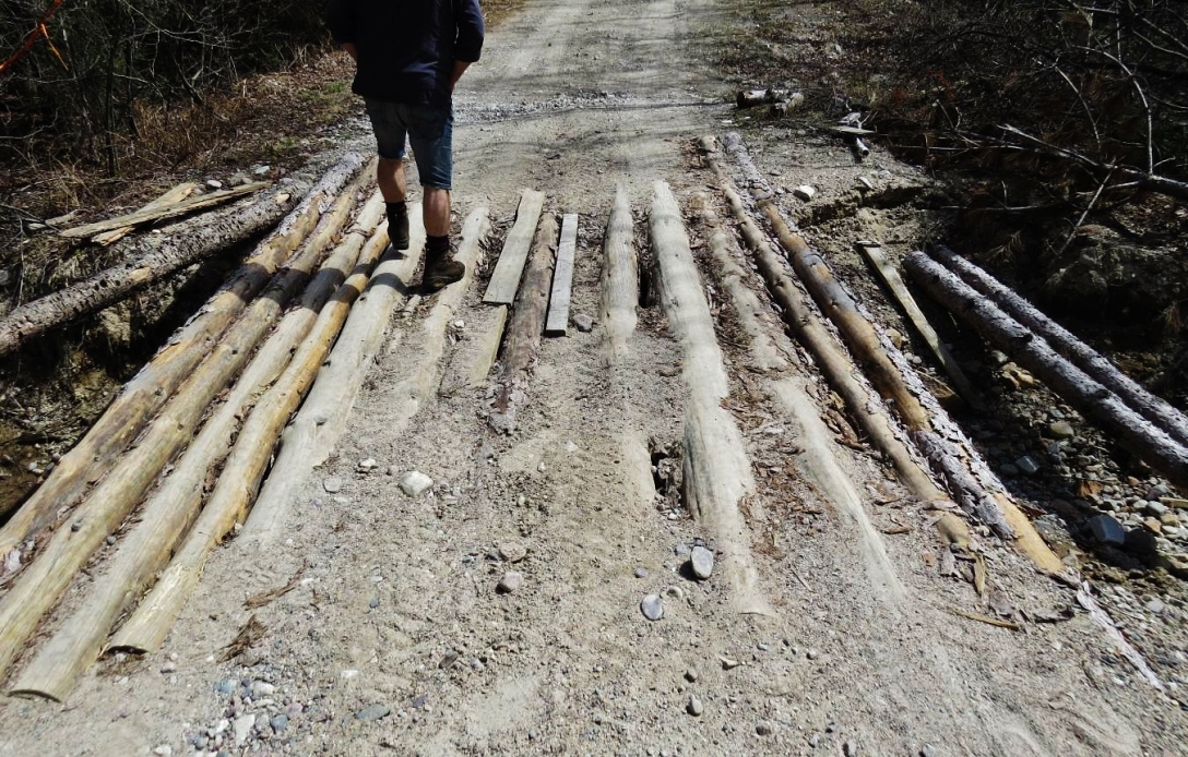
Current makeshift bridge, first washout, at about the 8km mark on the Boland Road.
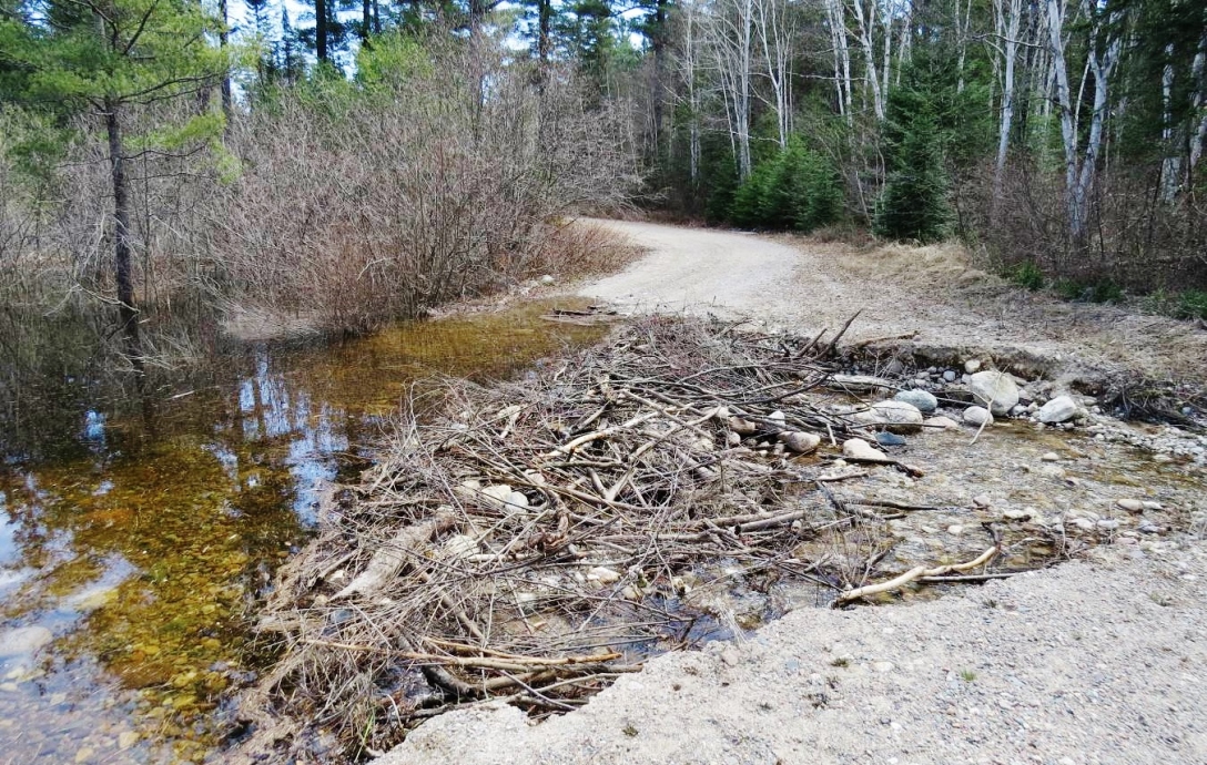
Second washout, about 1km after the first washout. An atv might be able to pass, through the water, on the left side of the beaver dam.
Ok, so, this is the last blog post that I have to do, in order to catch up on the backlog. The map above is not a complete GPS track of the hiking that I did, on this outing. I guess I should have turned the GPS on, as soon as I started hiking but, I didn’t. Therefore, this map only shows the location of the two falls that I visited today. A lot of people ask me if I know where the Puddingstone Falls are but, the actual name of these falls is not the Puddingstone Falls, nor is it the Boland Falls. The name of the falls is the Ceolin Falls, named after a Conservation Officer that did a lot of work to save this area for others to enjoy.
Having said that, the reason that many people call this the Puddingstone Falls is because, the area around these two falls is mostly puddingstone, which is basically a lot of smaller stones melted into one big mass of rock. Anyway, lets start at the beginning, before I get to the falls.
One of the difficulties in getting to these falls is certainly the old logging road, that goes in there. This old logging road is called the Boland Road and, it can be rather nasty, at times. I’ve seen it when it was completely flooded and, impassable. I’ve also seen large sections of the road that were washed out, usually by the spring meltdown. So, you are never guaranteed to be able to get in there. I will usually do a check on the road conditions in the late spring. This year, the road was not too bad. There were three washouts in the road but, with care, they were passable in my truck. However, low clearance vehicles would definitely have problems at these washouts.
It’s a fairly long drive on this road, to get to where the falls are located. And, even if you do get there, it’s not an easy place to find. Even though I’ve been to the falls before, I passed the trail, on the way in, simply because the bush is so thick. There are no markers at the trail to the falls, you just have to know where that trail is. There are signs but, they are not out near the road. There is a trail for both, the upper falls and, the lower falls. I measured the distance between the two entrances to be about 3/4 of a kilometer, along the Boland Road. However, there is also a trail, in the bush and, along the river, that runs between the two sets of falls.
Be warned, this drive will not be easy on your vehicle and, if you break down in here, no one is coming to help you. If you’re lucky, you might see another vehicle but, I wouldn’t count on it. Also, this is a very rugged area so, care must be taken, especially on the top of the falls. That rock up there can be very slippery and, since this is a remote wilderness area, there are no guard rails or, anything like that. Again, you are on your own and, you alone will be responsible for your own safety.
So, as I said, I passed right by the first entrance to the lower Ceolin Falls but, I soon realize that and, turned back. I drove very slowly until, there it was, a gravelly path, leading into the bush. Once you start in, on this path, you will soon see a sign. I wonder how many people have been fined $10,000. ? I expect no one since, this is a very remote location and, there is no oversight way out here.
The trail going into the lower falls is not too bad. There are some rugged sections but, I expect that most people, with no disabilities, could manage it. It’s not that long either and, you will come to the falls shortly.
 There is a large pool, below the falls, which might provide some good fishing. I’ve never fished here myself but, I have encountered folks, who were looking for this falls, for the purpose of fishing.
 You will probably soon realize, as I did that, the best view of the falls can probably be had on the other side of the river. In this shot, you can only see half of the falls. But, it’s not so easy to get across the river. I looked up river and, down river and, I found no easy way to cross. I think that the next time I come here, I’ll bring one of my small kayaks and, just paddle across this pond area.
I wanted to have one more look, to see if I could find a way to cross the river but, I couldn’t.
 I was using both the Canon Rebel T3i and, the Canon SX50 on this outing.
 Down river, there were all these big rocks and, I tried to find a path, by hopping from rock to rock, that would take me all the way across but, it became too risky. A fall here would almost certainly mean broken bones.
 I made my way back to the falls and, now, I was going to look for a trail to the top of the falls.
 There is a rugged trail, leading to the top of the falls and, this is what I saw, once I got there.
 The angle of the plaque and, the angle of the sun, made it a bit difficult to get a good shot of it but, you can click on any of these pictures to enlarge them.
From the top of the lower falls.
 The top of the lower falls. If you look in the water, you can clearly see that the rock is all puddingstone.
 Here’s a closer look.
From here, I would go back into the bush, to see if I could find a trail that leads to the upper falls.
 I did find a trail but, it wasn’t exactly a well-worn path. I would follow it anyway.
 The path wasn’t clear, in some places but, all I had to do was, keep the river in sight.
 Give or take, it was close to one kilometer long but, in bush like this, it seemed longer.
 There was a beat up marker, on the trail, to indicate that I was on the correct trail.
Eventually, I could hear the falls ahead.
 As I step out of the bush, the upper Ceolin Falls come into view.
 In my opinion, the upper Ceolin Falls has the best puddingstone. When it’s covered in water, it’s much more colorful.
At the top of the upper falls.

 I was going to turn on my GPS and, create a track, on the hike back out but, when I was here, I realized that there was another trail, leading back out to the Boland Road so, I decided to go out that way. It was easier and, faster, to walk back to the truck along the road.
Anyway, now you know where these falls are and, what you will need to go through, in order to get there. It really is worth coming here. The pictures never do these places justice.

We drove an F250 super duty through the make-shift log pass. We got past just fine. Well worth it to see the falls 😀
You took a risk that I believe most people wouldn’t take. I know of at least one pickup truck that didn’t make it across that bridge. I’ve seen the falls a number of times before, so it wasn’t worth the risk to me. Everyone who drives down there will have a choice to make. 🙂
I see you went to puddingstone falls/ceolin falls and wondered if you could tell me how to get there? I live in elliot lake but cannot find them even though thought i went the right way. Thanks in advance
Hey pixie, yes, the falls are very difficult to locate, unless you already know where they are. I did put a Google Map up on the blog post, but even so, you could have trouble finding the falls. There is no sign at the trail that leads into the falls, so even when I go, I have to slowly drive along that section, until I see the trails. Many times there will be vehicle parked on the side of the road there, which is a sure tip off. If you have a GPS, then it might be easier to find the falls, but remember there are two sets of falls, the upper and the lower falls. The lower falls is a straight down drop, whereas the upper falls is more of a slope, but they are both worth seeing. There is a trail you can take that leads from one falls to the other. If there’s anything else I can do, please let me know.